Areas and neighborhoods
Living in Dunnellon
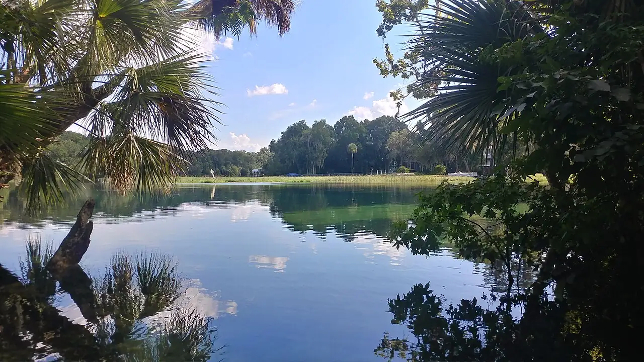
Dunnellon is the part of Marion County that is about water rather than horses, and it is far enough from Ocala to be its own place rather than a suburb of it.
Bottom line
- It is a small incorporated city with its own millage: 17.8671 mills proposed for 2026, against 15.5871 for unincorporated county west of Interstate 75.
- The rivers are the point. The Rainbow River is spring-fed and runs at a constant temperature into the Withlacoochee, and a large share of what people do here is on or in that water.
- About 18 straight-line miles from Ocala and about 32 from the Gulf at Inglis — the only part of Marion County that is genuinely closer to salt water than to the interstate.
Most of Marion County is about land — pasture, oaks, horses, acreage. Dunnellon is about water, and that makes it the most distinct place in the county.
Where it is, and how far that is
| Straight-line miles from Dunnellon | Miles |
|---|---|
| Ocala | 18 |
| Inglis, on the Gulf | ~14 |
| Crystal River | ~19 |
Those are great-circle distances from Census Gazetteer internal points; the road trip is longer. The Ocala figure is the one that matters day to day, and 18 miles in a county with no transit is a real commute rather than a hop.
It is also worth noticing the other two rows. Dunnellon is closer to the Gulf than it is to Ocala. That is true of nowhere else in this county, and it changes what a weekend looks like.
The rivers
The Rainbow River rises from a first-magnitude spring group just north of the town and runs a few miles south to join the Withlacoochee, which then forms part of the county line and eventually reaches the Gulf.
Spring-fed means constant temperature, year round. Cold on an August afternoon when nothing else in Florida is, and comparatively warm in January. The water is famously clear, because it has come up through limestone rather than run off a landscape.
What people actually do with that: swim, tube, paddle, snorkel, and sit beside it. Rainbow Springs State Park is the main public access and the state park system is the authority on hours, fees and conditions — those change, and an article is the wrong place to learn them.
For a county with no coastline, this is a large part of the answer to "what about water", and it is a better answer than the coast for a hot afternoon: closer, cooler, and quieter. See beaches within reach of Ocala for the salt-water version.
The taxing district
Dunnellon is an incorporated city, which distinguishes it from the platted communities elsewhere in the county. It has its own government and its own millage.
| 2026 proposed millage | Rate |
|---|---|
| Unincorporated county, west of Interstate 75 | 15.5871 |
| Dunnellon | 17.8671 |
| Belleview | 17.6133 |
| Ocala, lowest city district | 17.3710 |
About 2.3 mills above unincorporated county — roughly $575 a year on a $250,000 taxable value — and it buys city services. Comparable to the other small cities in the county.
The ad valorem rate is half the bill as always; Marion County property taxes explained covers the other half.
Flood, which is not optional here
A town at the confluence of two rivers has mapped flood risk, and riverfront property — the thing people move here for — is exactly the category where it bites.
Check the specific parcel on FEMA's Map Service Center before you make an offer. If it is in a mapped high-risk zone:
- a federally backed mortgage will require flood insurance;
- an elevation certificate from a licensed surveyor drives the premium, and an existing one saves you a survey;
- flood is never covered by a standard homeowners policy, in any zone.
And outside the mapped zone, FEMA's own consumer site reports that almost a third of NFIP claims come from outside high-risk areas — so price the cover rather than skip it. Flood zones in Marion County goes through the letters and what they mean.
What living there is actually like
Small. The town itself is compact, with a historic core, and the population it serves spreads out into the surrounding unincorporated county in both Marion and neighbouring counties.
The trade is distance. Marion County's employment, its hospitals and most of its retail are toward the middle and north of the county. From Dunnellon those are a planned trip. For a retired household or a remote worker that is a mild inconvenience. For a household with two jobs in Ocala and children in activities up there, it is the central fact of the week.
The upside is the pace and the water. It is quieter than anywhere else in the county with a name, it is genuinely a river town rather than a subdivision with a pond, and people who move there for the river tend to stay.
Schools and crime
As everywhere on this site: links, not rankings.
School assignment is by attendance zone, set by the address. Confirm it with the district for the exact parcel.
Crime data is published by FDLE and the Marion County Sheriff's Office; an incorporated city may also have its own police agency, and that is a question for the city. This site links the official sources and characterises no area — the reasoning is on the editorial policy page.
Sources
- Marion County Property Appraiser — Property Tax Estimator — 2026 proposed millage: Dunnellon taxing district 17.8671 mills; unincorporated county west of Interstate 75 15.5871 mills. The page states it excludes non-ad valorem assessments (retrieved September 18, 2026)
- U.S. Census Bureau — 2024 Gazetteer Files, Florida places — internal point coordinates for Dunnellon, Ocala, Inglis and Crystal River, from which the straight-line distances on this page are computed. Great-circle miles, not road miles (retrieved September 18, 2026)
- FEMA Flood Map Service Center — flood zone determination by address, which is not optional at a river confluence (retrieved September 18, 2026)
- Florida State Parks — Rainbow Springs State Park and river access; hours, fees and conditions (retrieved September 18, 2026)
- Florida Department of Environmental Protection — Florida Geological Survey — the spring systems and karst geology that produce the Rainbow River (retrieved September 18, 2026)
- Marion County Property Appraiser — parcel records: taxing district, year built, assessed value and exemptions (retrieved September 18, 2026)
- Marion County Public Schools — attendance zones, set by address (retrieved September 18, 2026)
Common questions
Where is Dunnellon?
At the south-western corner of Marion County, on the county line, where the spring-fed Rainbow River joins the Withlacoochee. It is an incorporated city, so it has its own government and its own millage, and it is about 18 straight-line miles from Ocala by Census Gazetteer internal points.
Is Dunnellon a good place to live?
This site does not rank places against each other. Descriptively: it is small, it is a genuine river town, it is a long way from the rest of the county's employment and services, and the water is the organising fact of daily life. People who move there for the river are generally happy; people who move there for the house price and then find they are driving to Ocala every day generally are not.
What is the property tax rate in Dunnellon?
The 2026 proposed millage for the Dunnellon taxing district is 17.8671 mills, against 15.5871 for unincorporated county west of Interstate 75. That is about 2.3 mills, or roughly $575 a year on a $250,000 taxable value, and it buys city services. Non-ad valorem assessments are billed separately and are in no millage rate.
Can you swim in the Rainbow River?
Yes, and it is one of the main reasons people live there. It is spring fed, which means it holds a near-constant temperature year round — cold in August and comparatively warm in January. Access is through Rainbow Springs State Park and other public points, and the state park system is the authority on hours, fees and current conditions.
Is Dunnellon in a flood zone?
Parts of it are, which is what you would expect where two rivers meet, and parts of it are not. This is a place where checking FEMA's Map Service Center for the specific parcel is not optional. Riverfront property is desirable here and desirable riverfront property is exactly the category where flood insurance, elevation certificates and base flood elevations matter.